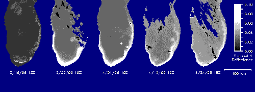
Reprinted courtesy of NOAA Office of Public Affairs. In spring, unseen by those fishing or frolicking on the shores of Lake Michigan, a mysterious phenomenon snakes a narrow, 60-mile-long path along the lake's southwestern shore, eventually turning north and disappearing in spiraling patterns along the eastern shoreline.Visible only from a NOAA environmental satellite 450 miles above the lake and first observed in 1980, its exact nature still eludes scientists. But all this may soon change if scientists can successfully plan and carry out studies to determine the precise nature, causes, and potential effects of this mysterious visitor. According to Brian Eadie, a scientist at NOAA's Great Lakes Environmental Research Laboratory in Ann Arbor, Mich., coordinating the studies, the phenomenon is an extensive, recurrent coastal plume of muddy water that occurs usually after the melting of shore ice and the onset of spring storms. Using a link to NOAA's nationwide CoastWatch network for a frame-by-frame analysis of NOAA satellite images, scientists at the Great Lakes Environmental Research Laboratory have tracked the development and dissipation of the plume from mid-March to late-April of this year. Because water in the plume reflects back more light relative to water elsewhere in the lake, a lighter, detectable outline of the plume could be followed over time. However, while satellite imagery provides a reliable way of monitoring the plume, two big questions still remain: What makes up the plume? Where did it come from? To answer these questions, GLERL and university scientists, together with a helicopter flight crew at the U.S. Coast Guard's Ninth District Air Station in Traverse City, Mich., teamed up to collect samples of the plume's waters by air and sea this past April. Physical, chemical, and biological analyses by the 13-member scientific group revealed much about the nature of the plume and potential effects on the Lake Michigan food chain. The plume was found to consist of very small clay and silt-sized particles that were most likely carried up into lake waters when spring storms and strong north winds produced high waves and currents that eroded fine material from the southwestern shore of Lake Michigan. Scientists determined that total suspended matter, the concentration of free-floating particles in water, was uniformly higher than that of surrounding waters. How big was the plume and how much material was carried within it? Scientists estimated it to be as much as 6 miles wide and at least 60 miles long, eventually stretching some 200 miles. Scientists estimated that 300,000 tons of material were transported and eventually deposited on Lake Michigan's southeastern shore. By comparison, the largest (1000-foot) Great Lakes freighters carry a cargo of 70,000 tons, meaning the entire plume would amount to the cargo capacity of about 4.3 ofthese freighters. What's the impact of the plume on the ecology of Lake Michigan? Preliminary data on the community of microscopic plants and animals within the plume indicate that conditions there promote biological activity, possibly by providing increased supplies of phosphorus. Added phosphorus contributed by the plume, coupled with spring warming of lake water and increased sunlight may lead to higher overall food chain productivity in those years when the plume develops. In addition, because the tiny clay and silt particles of the plume will readily bind with PCB's or other contaminants in the lake water, the plume phenomenon may represent a natural mechanism that may help strip such harmful contaminants from lake water.
|